TORONTO — Hurricane Florence is churning towards the U.S. East Coast as a Category 4 storm as Isaac beelines for the Caribbean and Olivia heads for Hawaii, prompting airlines including Air Canada and WestJet to issue travel advisories and waive change fees for a growing list of destinations.
Florence, currently a Category 4 hurricane and forecast to ramp up to a Category 5, is heading straight for South Carolina, North Carolina and Virginia. Landfall is expected in the very early hours of Sept. 14.
Air Canada is waiving change fees for travellers who purchased an Air Canada ticket no later than Sept. 10 for travel Sept. 12 – 16, with an itinerary that includes a flight to or from North Carolina, South Carolina, Virginia or Georgia.
WestJet’s advisory applies to Myrtle Beach-bound passengers, for travel on Sept. 14.
Meanwhile Isaac, tipping between tropical storm and hurricane status, is heading for the Lesser Antilles islands in the Caribbean, potentially by Sept. 13. WestJet is waiving change fees for Bridgetown flights Sept. 14, while Air Canada’s Bridgetown advisory applies to tickets purchased no later than Sept. 10, for travel Sept. 12 – 14. Carnival is also keeping an eye on the storm, making port adjustments to its Sept. 8 Carnival Vista itinerary.
And in Hawaii, just recently shaking off the wind and rain from Hurricane Lane, Air Canada’s advisory for Tropical Storm Olivia applies to tickets purchased no later than Sept. 10 for travel between now and Sept. 13, for any flight to or from Hawaii. WestJet’s advisory applies to travel to/from Hawaii Sept. 11 – 13.
The biggest storm of the three so far is Florence and in the U.S. mandatory evacuations are in place for parts of North Carolina, South Carolina and Virginia.
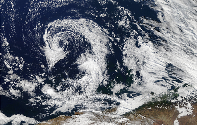
Hurricane Florence’s top winds dipped to 215 kph this morning, but it remains a Category 4 storm and is expected to approach the most-damaging Category 5 status as it slows and strengthens over very warm ocean water off the coast of North and South Carolina.
The centre of the massive storm is then forecast to meander Thursday, Friday and Saturday over a stretch of coastline saturated by rising seas, inundating several states with rainfall and triggering life-threatening floods.
The size of Florence is “staggering,” says National Hurricane Center Director Ken Graham.
“We could cover several states easily with the cloud cover alone,” he added. “This is not just a coastal event.”
Rainfall will be extremely heavy, dumping up to 10 to 20 inches over the next seven days over much of North Carolina and Virginia, and up to 30 inches in some places. Combined with high tides, the storm surge could reach 12 feet at the centre of the storm, say forecasters.
North Carolina Gov. Roy Cooper said his state is “in the bullseye” and urged people to “get ready now.”
South Carolina’s governor ordered the state’s entire coastline evacuated starting at noon today and predicted that one million people would flee as highways reverse directions. Virginia’s governor ordered a mandatory evacuation for some residents of low-lying coastal areas, while some coastal counties in North Carolina have done the same.
Tuesday’s seven-day rainfall forecast showed 20 inches or more falling there, part of a wide swath of rainfall that could total 10 inches or more over much of Virginia and drench the nation’s capital.
Florence could hit the Carolinas harder than any hurricane since Hazel packed 209 kph winds in 1954. That Category 4 storm destroyed 15,000 buildings and killed 19 people in North Carolina. In the six decades since then, many thousands of people have moved to the coast.
Watches were in effect today for a storm surge that could reach up to 12 feet at high tide on a stretch from Cape Fear to Cape Lookout in North Carolina, forecasters said. A hurricane watch was in effect for Edisto Beach, South Carolina, to Virginia’s southern border, and the first hurricane-force winds arriving late Thursday.
Florence is expected to linger once onshore, downing trees, knocking out electricity and causing widespread flooding.
A warm ocean is the fuel that powers hurricanes, and this area of the ocean is seeing temperatures peak near 85 degrees (30 Celsius), says hurricane specialist Eric Blake. And with little wind shear to pull the storm apart, Florence’s hurricane-strength winds are expanding, reaching 64 kilometres from the eye of the storm.
“Unfortunately, the models were right. Florence has rapidly intensified into an extremely dangerous hurricane,” said Blake, predicting that the hurricane’s top sustained winds would approach the 253 kph threshold for a wost-case Category 5 scenario.
By 8 a.m. this morning Florence was centred about 1,530 kilometres east-southeast of Cape Fear, North Carolina, and moving west-northwest at 24 kph. Its centre will move between Bermuda and the Bahamas on Tuesday and Wednesday and approach the coast of South Carolina or North Carolina on Thursday.
With files from The Associated Press
